การเพิ่มประสิทธิภาพการจัดสรรตำแหน่ง
ตัวอย่างนี้แสดงวิธีที่เราจัดการกับปัญหาการมอบหมายงานจำนวนมากและการจัดสรรสถานที่โดยใช้ Python แบบโอเพ่นซอร์ส ขั้นตอนการทำงานใช้ข้อมูลที่ไม่ระบุชื่อและสาธิตวิธีที่เราเตรียมอินพุตโมเดล สร้างเมทริกซ์ต้นทาง-ปลายทาง แก้ปัญหาการปรับให้เหมาะสม และส่งออกเอาต์พุตกลับไปยัง GeoJSON เพื่อให้สามารถตรวจสอบได้ในซอฟต์แวร์ GIS
คำถามในการวางแผนนั้นเรียบง่ายแต่มีประโยชน์: เมื่อพิจารณาจากประชากรในแต่ละละแวกใกล้เคียงหรือชานเมือง ความจุของสถานที่แต่ละแห่ง และระยะทางสูงสุดที่แต่ละสถานที่สามารถรองรับได้ มีสิ่งอำนวยความสะดวกเพียงพอที่จะให้บริการประชากรเต็มจำนวนหรือไม่ และถ้าไม่ พื้นที่ใดที่ยังคงไม่ได้รับมอบหมายภายใต้ข้อจำกัดในปัจจุบัน
นางแบบทำอะไร
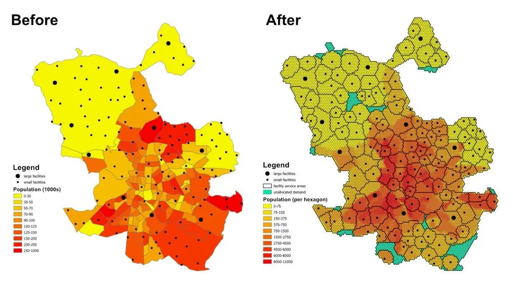
นี่คือรูปแบบการมอบหมายและการจัดสรรสถานที่ ตำแหน่งความต้องการแต่ละแห่งจะแสดงด้วยรูปหกเหลี่ยม แต่ละสถานที่แสดงถึงอุปทานที่มีอยู่ และแบบจำลองจะกำหนดทุกรูปหกเหลี่ยมให้กับสถานที่ที่เหมาะสมที่สุดแห่งเดียว ในขณะเดียวกันก็เคารพกฎระยะทางในการให้บริการและความจุ รูปแบบการสร้างแบบจำลองเดียวกันนี้สามารถนำไปใช้กับสถานพยาบาล โรงเรียน ธนาคาร ร้านค้าปลีก หรือเครือข่ายบริการอื่นๆ ที่เราจำเป็นต้องเข้าใจความครอบคลุม พื้นที่ให้บริการ และช่องว่างในการเข้าถึง
ผลลัพธ์ไม่ได้เป็นเพียงตารางการมอบหมายงานเท่านั้น นอกจากนี้ยังสามารถเปลี่ยนเป็นเลเยอร์พื้นที่ให้บริการและพื้นที่การค้าที่แสดงสถานที่แต่ละแห่งที่ครอบคลุมที่เป็นไปได้ พื้นที่ความต้องการใดถูกผลักดันไปยังทางเลือกสำรองที่ยังไม่ได้กำหนด และผลลัพธ์จะเปลี่ยนแปลงอย่างไรเมื่อมีการปรับความจุ ระยะทาง หรือวัตถุประสงค์
ฟังก์ชั่นวัตถุประสงค์
สำหรับตัวอย่างนี้ วัตถุประสงค์คือเพื่อลดระยะทางทั้งหมดจากรูปหกเหลี่ยมความต้องการทั้งหมดไปยังโรงงานที่ได้รับมอบหมายให้เหลือน้อยที่สุด ที่ให้การจัดสรรที่มีประสิทธิภาพสูงสุดภายใต้สมมติฐานปัจจุบัน กรอบงานเดียวกันสามารถรันใหม่ได้ด้วยฟังก์ชันวัตถุประสงค์ที่แตกต่างกันหากคำถามทางธุรกิจเปลี่ยนไป ตัวอย่างเช่น เราสามารถลดต้นทุนการดำเนินงานแทนระยะทาง ลดเวลาในการเดินทางแทนระยะทางเส้นตรง หรือปรับสมดุลความต้องการเพื่อให้สิ่งอำนวยความสะดวกที่มีต้นทุนสูงกว่าได้รับปริมาณเพียงพอที่จะปรับรูปแบบการดำเนินงานให้เหมาะสม
ข้อจำกัดที่สำคัญ
- สิ่งอำนวยความสะดวกแต่ละแห่งมีระยะการให้บริการสูงสุด ดังนั้นจึงไม่สามารถกำหนดความต้องการที่อยู่นอกช่วงนั้นได้
- สิ่งอำนวยความสะดวกแต่ละแห่งมีขอบเขตจำนวนประชากรขั้นต่ำและสูงสุด ดังนั้นความต้องการรวมที่ได้รับมอบหมายจะต้องอยู่ภายในขีดจำกัดกำลังการผลิต
- แต่ละรูปหกเหลี่ยมความต้องการจะต้องถูกกำหนดให้กับสถานที่แห่งเดียว
- หากไม่สามารถกำหนดรูปหกเหลี่ยมให้กับสถานที่จริงใดๆ ได้ ก็สามารถจัดสรรให้กับสถานที่จำลอง
unassignedเพื่อให้แบบจำลองยังคงเป็นไปได้และมองเห็นช่องว่างความครอบคลุมได้ - ตัวอย่างใช้ระยะทางแบบยุคลิดระหว่างเซนทรอยด์หกเหลี่ยมและสิ่งอำนวยความสะดวกสำหรับการสร้างต้นแบบอย่างรวดเร็ว แต่ขั้นตอนการทำงานเดียวกันสามารถเปลี่ยนเป็นเส้นทางที่ขับเคลื่อนได้จริงเมื่อจำเป็น
ขั้นตอนการทำงาน
ขั้นตอนการทำงานมีสามขั้นตอนหลัก:
- แปลงพื้นที่ที่สนใจให้เป็นเทสเซลเลชันหกเหลี่ยม แล้วหาจำนวนประชากรของรูปหกเหลี่ยมแต่ละอัน
- สร้างเมทริกซ์ต้นทาง-ปลายทางระหว่างรูปหกเหลี่ยมความต้องการแต่ละอันกับสถานที่แต่ละแห่ง
- แก้ไขโมเดลการปรับให้เหมาะสมและส่งออกผลลัพธ์ไปยัง GeoJSON เพื่อให้สามารถตรวจสอบได้ใน QGIS, ArcGIS Pro หรือซอฟต์แวร์แผนที่อื่นๆ
สแต็กการใช้งานประกอบด้วย Python โอเพ่นซอร์สที่มีรูปทรง, pyproj, sqlite3, pyomo, ตัวแก้ปัญหา CBC และเอาต์พุต GeoJSON รูปแบบการเตรียมข้อมูลเป็นแบบโมดูลาร์โดยเจตนา ซึ่งทำให้ง่ายต่อการแทนที่ชั้นความต้องการ เปลี่ยนข้อจำกัดด้านสิ่งอำนวยความสะดวก สลับวัตถุประสงค์ หรือขยายโมเดลด้วยกฎเกณฑ์ทางธุรกิจเพิ่มเติม
บันทึกการใช้งาน- เดิมที PuLP ได้รับการทดสอบ แต่เลือก pyomo แทน เนื่องจากสามารถจัดการกับโมเดลที่ใหญ่กว่ามากได้อย่างน่าเชื่อถือมากกว่า
- โมเดลได้รับการแก้ไขด้วยโปรแกรมแก้ปัญหา CBC แบบโอเพ่นซอร์ส และแนวทางนี้ได้ปรับขนาดตัวแปรการตัดสินใจมากกว่า 50 ล้านตัวแปรในเวลาไม่ถึงหนึ่งชั่วโมงด้วยการตั้งค่านั้น
- สำหรับกรณีที่มีขนาดใหญ่กว่านั้น gurobi สามารถพิจารณาได้ในกรณีที่ใบอนุญาตอนุญาต
- การเขียนเอาต์พุตขนาดใหญ่ไปยัง GeoJSON อาจใช้เวลานานกว่าการแก้ไขโมเดล ดังนั้นสำหรับการดำเนินการผลิตที่ใหญ่กว่า การเขียนลงในฐานข้อมูลโดยตรงจะมีประสิทธิภาพมากกว่า
- วิธีปฏิบัติจริงในการสร้างแบบจำลองเช่นนี้คือการเริ่มต้นด้วยรูปหกเหลี่ยมขนาดใหญ่และระยะทางแบบยุคลิดที่รวดเร็วในขณะที่ทดสอบข้อจำกัด จากนั้นเปลี่ยนไปใช้เทสเซลเลชันที่ละเอียดยิ่งขึ้นและต้นทุนเส้นทางที่สมจริงมากขึ้น เมื่อพฤติกรรมของแบบจำลองได้รับการตรวจสอบแล้ว
- ข้อจำกัดเพิ่มเติมสามารถเพิ่มได้ทีละน้อย แต่ควรนำมาใช้อย่างระมัดระวัง เนื่องจากกฎทางธุรกิจพิเศษแต่ละข้อจะเพิ่มความเสี่ยงในการทำให้แบบจำลองเป็นไปไม่ได้
ตัวอย่างซอร์สโค้ด
โค้ดด้านล่างแสดงขั้นตอนการทำงานตั้งแต่ต้นทางถึงปลายทางโดยตรงบนหน้านี้
1. Generate_hexagons.py
import json
import math
import os
import pyproj
from shapely.geometry import shape

# for converting the coordinates to and from geographic and projected coordinates
TRAN_4326_TO_3857 = pyproj.Transformer.from_crs("EPSG:4326", "EPSG:3857")
TRAN_3857_TO_4326 = pyproj.Transformer.from_crs("EPSG:3857", "EPSG:4326")

# the area of interest used for generating the hexagons
input_geojson_file = "input/area_of_interest.geojson"

# load the area of interest into a JSON object
with open(input_geojson_file) as json_file:
    geojson = json.load(json_file)

# the area of interest coordinates (note this is for a single-part / contiguous polygon)
geographic_coordinates = geojson["features"][0]["geometry"]["coordinates"]

# create an area of interest polygon using shapely
aoi = shape({"type": "Polygon", "coordinates": geographic_coordinates})

# get the geographic bounding box coordinates for the area of interest
(lng1, lat1, lng2, lat2) = aoi.bounds

# get the projected bounding box coordinates for the area of interest
[W, S] = TRAN_4326_TO_3857.transform(lat1, lng1)
[E, N] = TRAN_4326_TO_3857.transform(lat2, lng2)

# the area of interest height
aoi_height = N - S

# the area of interest width
aoi_width = E - W

# the length of the side of the hexagon
l = 200

# the length of the apothem of the hexagon
apo = l * math.sqrt(3) / 2

# distance from the mid-point of the hexagon side to the opposite side
d = 2 * apo

# the number of rows of hexagons
row_count = math.ceil(aoi_height / l / 1.5)

# add a row of hexagons if the hexagon tessallation does not fully cover the area of interest
if(row_count % 2 != 0 and row_count * l * 1.5 - l / 2 < aoi_height):
    row_count += 1

# the number of columns of hexagons
column_count = math.ceil(aoi_width / d) + 1

# the total height and width of the hexagons
total_height_of_hexagons = row_count * l * 1.5 if row_count % 2 == 0 else 1.5 * (row_count - 1) * l + l
total_width_of_hexagons = (column_count - 1) * d

# offsets to center the hexagon tessellation over the bounding box for the area of interest
x_offset = (total_width_of_hexagons - aoi_width) / 2
y_offset = (row_count * l * 3 / 2 - l / 2 - aoi_height - l) / 2

# create an empty feature collection for the hexagons
feature_collection = { "type": "FeatureCollection", "features": [] }

oid = 1

hexagon_count = 0

for i in range(0, column_count):
    for j in range(0, row_count):
        if(j % 2 == 0 or i < column_count - 1):
            x = W - x_offset + d * i if j % 2 == 0 else W - x_offset + apo + d * i
            y = S - y_offset + l * 1.5 * j

            coords = []

            for [lat, lng] in [
                TRAN_3857_TO_4326.transform(x, y + l),
                TRAN_3857_TO_4326.transform(x + apo, y + l / 2),
                TRAN_3857_TO_4326.transform(x + apo, y - l / 2),
                TRAN_3857_TO_4326.transform(x, y - l),
                TRAN_3857_TO_4326.transform(x - apo, y - l / 2),
                TRAN_3857_TO_4326.transform(x - apo, y + l / 2),
                TRAN_3857_TO_4326.transform(x, y + l)
            ]:
                coords.append([lng, lat])

            hexagon = shape({"type": "Polygon", "coordinates": [coords]})

            # check if the hexagon is within the area of interest
            if aoi.intersects(hexagon):
                hexagon_count += 1
                if(hexagon_count % 1000 == 0):
                    print('Generated {} hexagons'.format(hexagon_count))

                population = 0
                hexagon_names = []

                # open the geojson file with the population data
                with open("input/population_areas.geojson") as json_file:
                    geojson = json.load(json_file)

                    for feature in geojson["features"]:
                        polygon = shape(
                            {
                                "type": "Polygon",
                                "coordinates": feature["geometry"]["coordinates"]
                            }
                        )

                        # check if hexagon is within the polygon and derive the population for that intersected part of the hexagon
                        if hexagon.intersects(polygon):
                            if not feature["properties"]["Name"] in hexagon_names:
                                hexagon_names.append(feature["properties"]["Name"])

                            population += (
                                hexagon.intersection(polygon).area
                                / polygon.area
                                * feature["properties"]["Population"]
                            )

                hexagon_names.sort()

                f = {
                    "type": "Feature",
                    "properties": {
                        "id": oid,
                        "name": ', '.join(hexagon_names),
                        "population": population
                    },
                    "geometry": {
                            "type": "Polygon",
                            "coordinates": [coords]
                        }
                }

                # add the hexagon to the feature collection
                feature_collection['features'].append(f)

                oid += 1

print('Generated {} hexagons'.format(hexagon_count))

# output the feature collection to a geojson file
with open("output/hexagons.geojson", "w") as output_file:
    output_file.write(json.dumps(feature_collection))


# Play a sound when the script finishes (macOS)
for i in range(1, 2):
    os.system('afplay /System/Library/Sounds/Glass.aiff')

# Play a sound when the script finishes (Windows OS)
    # import time
    # import winsound

    # frequency = 1000
    # duration = 300

    # for i in range(1, 10):
    #     winsound.Beep(frequency, duration)
    #     time.sleep(0.1)
2. Generate_origin_destination_matrix.py
import json
import math
import os
import pyproj
import sqlite3

def getDistance(x1,y1,x2,y2):
    distance = math.sqrt((x2-x1)**2+(y2-y1)**2)
    return int(distance)

def getHexagonCentroid(hexagon):
    coordinates = hexagon['geometry']['coordinates'][0]

    # remove the last pair of coordinates in the hexagon
    coordinates.pop()

    lat = sum(coords[1] for coords in coordinates) / 6
    lng = sum(coords[0] for coords in coordinates) / 6

    return lat, lng

# for converting the coordinates to and from geographic and projected coordinates
TRAN_4326_TO_3857 = pyproj.Transformer.from_crs("EPSG:4326", "EPSG:3857")
TRAN_3857_TO_4326 = pyproj.Transformer.from_crs("EPSG:3857", "EPSG:4326")

# create a sqlite database for the results
db = 'output/results.sqlite'

# delete the database if it already exists
if(os.path.exists(db)):
    os.remove(db)

# create a connection to the sqlite database
conn = sqlite3.connect(db)

# create cursors for the database connection
c1 = conn.cursor()
c2 = conn.cursor()

# create the facilities table
c1.execute('''
    CREATE TABLE facilities (
        facility_id                     INT,
        facility_x                      REAL,
        facility_y                      REAL,
        trade_area_distance_constraint  REAL,
        min_population_constraint       INT,
        max_population_constraint       INT
    );
''')

c1.execute('''
    CREATE TABLE od_matrix (
        facility_id INT,
        hexagon_id  INT,
        facility_x  REAL,
        facility_y  REAL,
        hexagon_x   REAL,
        hexagon_y   REAL,
        distance    INT,
        optimal     INT
    );
''')

# the geojson for the facilities
input_geojson_file = "input/facilities.geojson"

# load the area of interest into a JSON object
with open(input_geojson_file) as json_file:
    geojson = json.load(json_file)

    facilities = geojson['features']

    for facility in facilities:
        facility_id = facility['properties']['OID']
        trade_area_distance_constraint = facility['properties']['trade_area_dist_constraint']
        min_population_constraint = facility['properties']['min_population_constraint']
        max_population_constraint = facility['properties']['max_population_constraint']

        [lng, lat] = facility['geometry']['coordinates']
        [x, y] = TRAN_4326_TO_3857.transform(lat, lng)

        sql = '''
            INSERT INTO facilities (
                facility_id,
                facility_x,
                facility_y,
                trade_area_distance_constraint,
                min_population_constraint,
                max_population_constraint
            )
            VALUES ({},{},{},{},{},{});
        '''.format(facility_id, x, y, trade_area_distance_constraint, min_population_constraint, max_population_constraint)

        c1.execute(sql)

# create an empty feature collection for the hexagons
feature_collection = { "type": "FeatureCollection", "features": [] }

# the geojson for the hexagons
input_geojson_file = "output/hexagons.geojson"

# load the area of interest into a JSON object
with open(input_geojson_file) as json_file:
    geojson = json.load(json_file)

    hexagons = geojson['features']

    for i, hexagon in enumerate(hexagons):
        hexagon_id = hexagon['properties']['id']
        lat, lng = getHexagonCentroid(hexagon)
        [hexagon_x, hexagon_y] = TRAN_4326_TO_3857.transform(lat, lng)

        rows = c1.execute('''
            SELECT facility_id, facility_x, facility_y, trade_area_distance_constraint
            FROM facilities;
        ''').fetchall()

        for row in rows:
            facility_id, facility_x, facility_y, trade_area_distance_constraint = row
            distance = getDistance(hexagon_x, hexagon_y, facility_x, facility_y)

            if(distance > int(trade_area_distance_constraint)):
                distance = 100000

            sql = '''
                INSERT INTO od_matrix(facility_id, facility_x, facility_y, hexagon_id, hexagon_x, hexagon_y, distance)
                VALUES ({},{},{},{},{},{},{});
            '''.format(facility_id, facility_x, facility_y, hexagon_id, hexagon_x, hexagon_y, distance)

            c2.execute(sql)

            (hexagon_lat, hexagon_lng) = TRAN_3857_TO_4326.transform(hexagon_x, hexagon_y)
            (facility_lat, facility_lng) = TRAN_3857_TO_4326.transform(facility_x, facility_y)

            coords = [[facility_lng, facility_lat],[hexagon_lng, hexagon_lat]]

            if(distance <= trade_area_distance_constraint):
                f = {
                    "type": "Feature",
                    "properties": {},
                    "geometry": {
                            "type": "LineString",
                            "coordinates": coords
                        }
                }

                # add the hexagon to the feature collection
                feature_collection['features'].append(f)


        if((i+1) % 1000 == 0):
            print('Processed {} hexagons'.format(i+1))


conn.commit()
conn.close()

# output the feasible facility-hexagon pairs to geojson
with open("output/routes.geojson", "w") as output_file:
    output_file.write(json.dumps(feature_collection))

for i in range(1,2):
    os.system('afplay /System/Library/Sounds/Glass.aiff')
3. solve_the_model.py
from pyomo.environ import *
from pyomo.opt import SolverFactory
import datetime
import json
import os
import pyproj
import sqlite3

# for converting the coordinates to and from geographic and projected coordinates
TRAN_4326_TO_3857 = pyproj.Transformer.from_crs("EPSG:4326", "EPSG:3857")
TRAN_3857_TO_4326 = pyproj.Transformer.from_crs("EPSG:3857", "EPSG:4326")

# the input database created from the previous script
db = 'output/results.sqlite'

# create a database connection
conn = sqlite3.connect(db)

# create a cursor for the database connection
c = conn.cursor()

# the demand, supply, and cost matrices
Demand = {}
Supply = {}
Cost = {}

'''
    Supply['S0'] is for infeasible results, i.e. hexagons that do not
    have any facilities when the nearest facility is too far away,
    or when the population constraint for the facilities means the
    hexagon cannot be assigned to that facility
'''
# the population capacity constraint of the "unassigned" facility
Supply['S0'] = {}
Supply['S0']['min_pop'] = 0
Supply['S0']['max_pop'] = 1E10

sql = '''
    SELECT DISTINCT hexagon_id
    FROM od_matrix
    ORDER BY 1;
'''

# the assignment constraint, i.e. each hexagon can only be assigned to one facility
for row in c.execute(sql):
    hexagon_id = row[0]
    d = 'D{}'.format(hexagon_id)
    Demand[d] = 1

    # the infeasible case for each hexagon
    Cost[(d,'S0')] = 1E4

sql = '''
    SELECT DISTINCT facility_id, min_population_constraint, max_population_constraint
    FROM facilities
    ORDER BY 1;
'''

# the facility capacity constraint - cannot supply more hexagons than the facility has capacity for
for row in c.execute(sql):
    [facility_id, min_population_constraint, max_population_constraint] = row
    s = 'S{}'.format(facility_id)
    Supply[s] = {}
    Supply[s]['min_pop'] = min_population_constraint
    Supply[s]['max_pop'] = max_population_constraint

sql = '''
    SELECT facility_id, hexagon_id, distance
    FROM od_matrix;
'''

# creating the Cost matrix
for row in c.execute(sql):
    (facility_id, hexagon_id, distance) = row
    d = 'D{}'.format(hexagon_id)
    s = 'S{}'.format(facility_id)
    Cost[(d,s)] = distance

print('Building the model')

# creating the model
model = ConcreteModel()
model.dual = Suffix(direction=Suffix.IMPORT)

# Step 1: Define index sets
dem = list(Demand.keys())
sup = list(Supply.keys())

# Step 2: Define the decision variables
model.x = Var(dem, sup, domain=NonNegativeReals)

# Step 3: Define Objective
model.Cost = Objective(
    expr = sum([Cost[d,s]*model.x[d,s] for d in dem for s in sup]),
    sense = minimize
)

# Step 4: Constraints
model.sup = ConstraintList()
# each facility cannot supply more than its population capacity
for s in sup:
    model.sup.add(sum([model.x[d,s] for d in dem]) >= Supply[s]['min_pop'])
    model.sup.add(sum([model.x[d,s] for d in dem]) <= Supply[s]['max_pop'])

model.dmd = ConstraintList()
# each hexagon can only be assigned to one facility
for d in dem:
    model.dmd.add(sum([model.x[d,s] for s in sup]) == Demand[d])

'''
    There is no need to add a constraint for the service/trade area distances
    for the facilities. We are already handling this when we generate
    the origin destination matrix. If any hexagon falls outside of all
    facility trade areas, then it gets assigned to the "unassigned" facility.
'''

print('Solving the model')

# use the CBC solver and solve the model
results = SolverFactory('cbc').solve(model)

# for c in dem:
#     for s in sup:
#         print(c, s, model.x[c,s]())

# if the model solved correctly
if 'ok' == str(results.Solver.status):
    print("Objective Function = ", model.Cost())
    print('Outputting the results to GeoJSON') # note it would be faster to write the results directly to a database, e.g. Postgres / SQL Server

    # print("Results:")
    for s in sup:
        for d in dem:
            if model.x[d,s]() > 0:
                # print("From ", s," to ", d, ":", model.x[d,s]())
                facility_id = s.replace('S','')
                hexagon_id = d.replace('D','')
                c.execute('''
                    UPDATE od_matrix
                    SET optimal = 1
                    WHERE facility_id = {}
                        AND hexagon_id = {};
                '''.format(facility_id, hexagon_id))

    # create an empty feature collection for the results
    feature_collection = { "type": "FeatureCollection", "features": [] }

    rows = c.execute('''
            SELECT facility_id, hexagon_id, facility_x, facility_y, hexagon_x, hexagon_y, distance
            FROM od_matrix
            WHERE optimal = 1;
        ''')

    for row in rows:
        (facility_id, hexagon_id, facility_x, facility_y, hexagon_x, hexagon_y, distance) = row
        (hexagon_lat, hexagon_lng) = TRAN_3857_TO_4326.transform(hexagon_x, hexagon_y)
        (facility_lat, facility_lng) = TRAN_3857_TO_4326.transform(facility_x, facility_y)

        coords = [[facility_lng, facility_lat],[hexagon_lng, hexagon_lat]]

        f = {
                "type": "Feature",
                "properties": {},
                "geometry": {
                        "type": "LineString",
                        "coordinates": coords
                    }
            }

        # add the route to the feature collection
        feature_collection['features'].append(f)

    # output the optimally assigned pairs to geojson
    with open("output/optimal_results.geojson", "w") as output_file:
        output_file.write(json.dumps(feature_collection))

    # update the hexagons
    with open('output/hexagons.geojson') as json_file:
        geojson = json.load(json_file)
        hexagons = geojson['features']

        for hexagon in hexagons:
            facility_id = -1
            hexagon_id = hexagon['properties']['id']

            sql = '''
                SELECT facility_id
                FROM od_matrix
                WHERE hexagon_id = {}
                    AND optimal = 1;
            '''.format(hexagon_id)

            row = c.execute(sql).fetchone()

            if row:
                facility_id = row[0]

            hexagon['properties']['facility_id'] = facility_id

        # load the area of interest into a JSON object
        with open("output/hexagon_results.geojson", "w") as output_file:
            output_file.write(json.dumps(geojson))

else:
    print("No Feasible Solution Found")

finish_time = datetime.datetime.now()
# print('demand nodes = {} and supply nodes = {} | time = {}'.format(no_of_demand_nodes, no_of_supply_nodes, finish_time-start_time))

conn.commit()
conn.close()

for i in range(1,2):
    os.system('afplay /System/Library/Sounds/Glass.aiff')