Geovez Enterprise
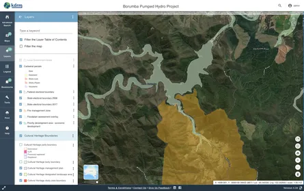
Geovez Enterprise is KDRM's enterprise geospatial product suite, combining an ArcGIS-compatible service and API layer, administrative tooling, a high-performance map viewer.
Read MoreWe design and build spatial and non-spatial products and tools. These include web mapping and mobile applications, static and dynamic websites, reporting tools and dashboards, web services, data services, optimisation models, and other automation and auditing tools.
When we work on projects, we are involved with all stages of each project. These stages include:
We offer different types of products depending on our clients' requirements. For example, we can provide our own products as subscription services, or alternatively we can build custom products as required. When we build custom products for our clients, we provide the source code to our clients, and documentation for deploying and maintaining the code. We are also in the process of building open-source tools that will be available for free via GitHub and similar platforms.
Geovez Enterprise is KDRM's enterprise geospatial product suite, combining an ArcGIS-compatible service and API layer, administrative tooling, a high-performance map viewer.
Read More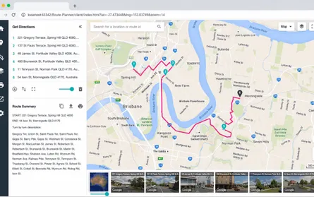
This route planning application allows users to create and manage multiple routes for multiple deliveries, review them on the map, and export the final routes and turn-by-turn instructions to GPS navigation devices for drivers.
Read More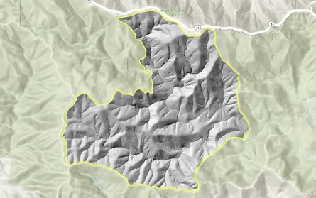
This example shows some of the raster and image-processing tools KDRM has created for clipping, resampling, validating, and automating raster workflows using open-source Python packages.
Read More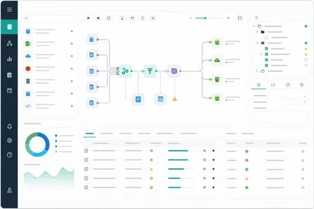
KDRM designs and builds custom ETL, migration, auditing, and reconciliation tools using FME, Alteryx, Python, and other custom-developed tooling for spatial and non-spatial enterprise environments.
Read More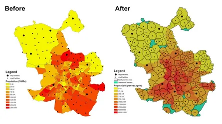
This example shows how a large assignment and location-allocation model can be prepared and solved in open-source Python, from tessellation and origin-destination matrix generation through to Pyomo optimisation and GeoJSON outputs.
Read More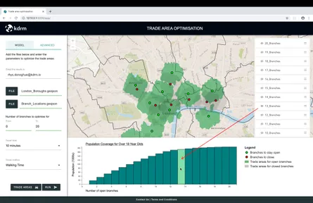
This example shows a simplified trade area optimisation model used to identify the best mix of branch locations by maximising population coverage while minimising overlapping trade areas.
Read More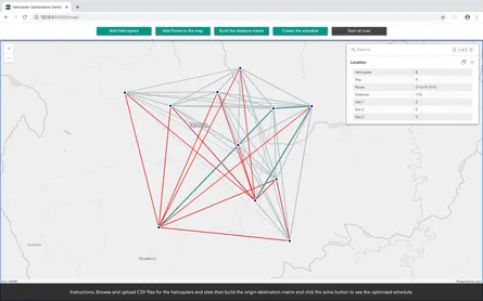
We design and build advanced route and schedule optimisation software for complex operational problems, including network analysis, distance matrix generation, resource assignment, routing, dispatch, and scheduling.
Read More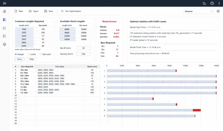
This optimisation model was developed to minimise waste when cutting reinforcing bars from straight stock lengths. By reducing waste from approximately 6-8% to about 0.5%, it can materially lower steel purchasing losses and associated handling and scrap costs.
Read More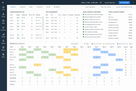
This nurse rostering optimisation model assigns nurses to shifts while enforcing coverage, manager presence, qualifications, availability, rest rules, maximum hours, and fairness across the roster.
Read More